


We, Tindak Malaysia, are committed to educating Malaysian citizens to learn about the electoral scene and the redelineation process. Leveraging on our GIS expertise, we hereby present Malaysia’s Online Electoral Map site. We believe this is a FIRST for Malaysia. Considering this information is free for the public, we would like to ask each user to contribute to us financially, and each user can email their interest to contribute any amount via info@tindakmalaysia.com
*Given the relatively small size of the Malaysian electoral field and the restricted sources of primary data, resultant analytics and maps would tend to be similar. Any similarities with other maps are entirely coincidental. Permission is required to source datasets for all the applications as below. We acknowledge the hard work of countless volunteers since 2013 who contributed to the Tindak mapping program. All the maps are strictly for non-commercial (inclusive media) usage only. We are not responsible for any misuse of the maps. We will not hesitate to take appropriate actions if the misuse damages our reputation. All the maps are to support the works of Persatuan Bertindak Pilihan Raya Bebas dan Saksama (“Tindak”)
- 2025 – Present Political Scene
- Malaysia Electoral and Administrative Map
- 2018 Present Political Scene
- Effect of Undi18 Implementation
- Malapportionment and Economics
- Mapping Political Demographics for GE14
- Comparing GE13 (2013) Boundaries and GE14 (2018 Boundaries)
- 2015/17 Electoral Map Scene
- Historical Electoral Maps
2025 – Present Political Scene
Below here is the latest map showing who the MPs/ State Legislative Assemblypersons (ADUN) are and the seats won by the various coalitions. This dynamic map is updated whenever there is a change in affiliation for the parliament/DUN seat (for example, death, disqualification of MP/ADUN, change in coalitions). For optimum view (Parliamentary), please view this link.
For DUN view, please view this link.
For the DUN, Ethnic Composition and Urban-Rural Classification, omissions for advocacy. Refer to data points of Melaka (2021), Sarawak (2021), Johor (2022), Perlis-Perak-Pahang (2022), Six States (2023), and Sabah (2025) elections.
We acknowledge the following sources for the maps: SPR, Parlimen Malaysia, Tindak Malaysia (for the DUN, SPR, DUN websites, District and Land Office (for Perak), Tindak Malaysia.
Sample Preview for Current Dewan Rakyat Scene (below)
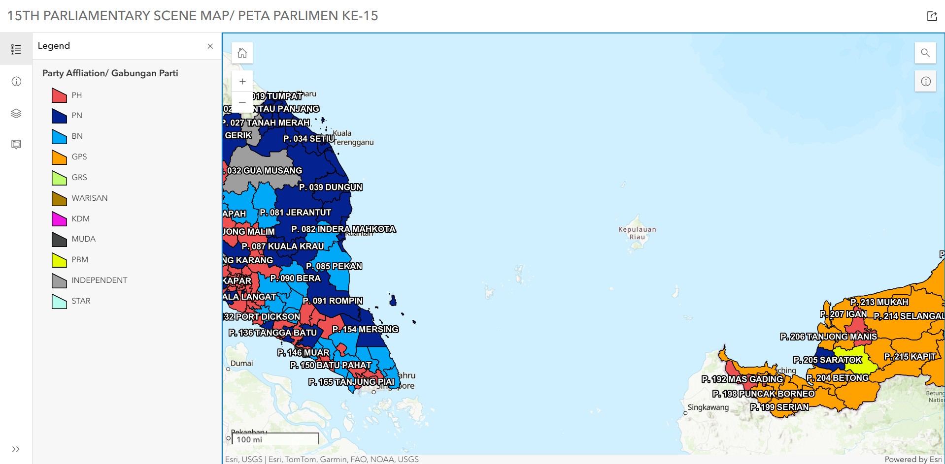
Sample preview of Current DUN Scene (below)
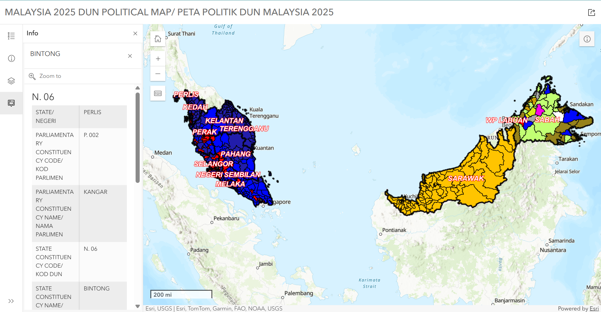
Malaysia Electoral and Administrative Map
This new map (optimal view), launched on 28th May 2026, shows the relationship between administrative, local authority, and electoral areas. In the first phase of this map application, three layer groups were included – administrative (Bahagian/ Daerah), local authorities (Pihak Berkuasa Tempatan), and electoral (Parlimen/DUN). We have included the official office website for these boundary tiers.
It is important to acknowledge that there are multiple interpretations of state boundaries, district boundaries, and electoral areas (and coastlines). We do not recognise the District of Selama as a distinct district of Perak and consider it as a subdistrict.
The map is produced by Danesh Prakash Chacko and S.M. Sabri.
For any issues, please email danesh@tindakmalaysia.com. Corrections will be made from time to time based on the seriousness of the error and urgency.
To the Top
2018 – 2023 Political Scene
Below here is the old map showing who are the MPs and the seats won by the various coalitions. The map is no longer valid upon the dissolution of the 14th Parliament in October 2022. The application has been retired.
We acknowledge the following Sources for the map: SPR Malaysia (2018), Parliament of Malaysia, PKR.
Effect of Undi18 implementation
Starting from 16th January 2022, EC will be automatically adding new voters to the electoral roll (for all qualified Malaysians of 18 years) on the 16th of every month. On 15th December 2021, the Bill related to Automatic Voter Registration and Registration of qualified Malaysians aged 18 to 21 came into effect. In January 2022, an estimated 5.6 million new voters (Malaysians 18 and above) were added to the roll. Below here is the visualization for the addition of new voters by parliamentary seat and the evolving voter population growth from 2016
We acknowledge the following Sources for the visualization: SPR Malaysia, PKR, Pra Pendaftaran Automatik (for 2nd Quarter 2021 statistics only), Wikipedia, Tindak Malaysia.
The visualization should be used as a guide only, as the 2022 electorate size is an estimate only.
Sabah’s parliamentary seat electorate size (2016 – 2019) reflects the 2016 redivision of polling district boundaries. Electorate size of Sabah’s parliamentary seats (2020 – present) reflects the 2019 redelineated boundaries. Lahad Datu was previously known as Silam before the Sabah State Elections.
The link to the visualization can be viewed (for a better viewing experience) by clicking here.
MALAPPORTIONMENT AND ECONOMICS
Is there a relationship between urbanization, constituency electorate size, and key economic indicators?
Check out our latest visualization
We acknowledge the following Sources for the visualization: SPR Malaysia, Department of Statistics, Malaysia (2022), Tindak Malaysia.
The link to the visualization can be viewed (for a better viewing experience) by clicking here.

Mapping Political Demographics for GE14
Using the simple visualization options of Tableau Public, we offer simple insights into Malaysian voter demographics that would be key in understanding the developments of GE14. These maps utilise the latest constituency boundaries and are labeled in Malay to obtain maximum readership.
Key Instructions
- Choose one of the following maps by clicking on the tabs above – Etnik Pengundi Malaysia [Voter ethnicity], Pengundi Belia Malaysia – [Youth voters], Pengundi Awal Malaysia – [Early Voters]
- Hover over one of the parliamentary areas and wait – the information will load up. You will see key insights on ethnicity, youth population, or presence of early voters, depending on the map selected
- Click on the search icon on the left-hand side of the map to key in your hometown or interested area. You will be zoomed into the area you selected
- Colour coding of the pie charts is explained in the Pecahan Etnik section
For the view of the application, please click on the link
Comparing GE13 (2013) and GE14 (2018) Boundaries
With the newly redelineated boundaries approved on 29th March 2018, we would like to share with you a simple interactive map application to see where the changes have occurred. Follow the instructions on the left-hand side of the Application. Assess how boundaries have changed and which seats experienced name changes.
**No parliamentary boundary amendments were done for Sabah, Sarawak (completed in 2015), and Labuan**
Click HERE for the Interactive Map Application
We acknowledge the following sources for the application: SPR Malaysia
2015/17 Electoral Map Scene
DUE TO A CHANGE OF CARTO, THIS MAP IS NO LONGER ACCESSIBLE
Below is the 2015/17 Electoral & Demographic Map of Malaysia. Hover to identify the Parliamentary Constituency and click for details. You can pan and zoom the map using your mouse and scroll wheel.
On your right-hand side, you will see the values change of average voter growth, ethnic majorities, and general party composition of the area. It is in a dynamic setting where it changes as you move around Malaysia.
We acknowledge the following sources for the application above: SPR Malaysia, The Malaysian Insight, Malaysiakini, Wikipedia, Bersih
*The boundaries are only valid till 29th March 2018. 13th Parliament, dissolved itself on 7th April 2018