


MIRI & SIBUTI: UNDERSTANDING POPULATION GROWTH PATTERNS

Miri District (which District of Subis (formerly Sibuti) used to be part of) is the second most populous district of Sarawak. In 2018, Department of Statistics, Malaysia (DOSM) estimated there is 347600 residents in the District of Miri (inclusive of Subis) and this accounts 12% of the population of Sarawak. As EC drawn the state constituency boundaries without any correspondence with existing local authority boundaries, there are 2 parliamentary seats fully in District of Miri and the upper part of Bintulu Parliamentary seat is found in the District of Subis. Following are the state constituencies (DUNs) found in the District of Miri (also, under Majlis Bandaraya Miri – Miri City Council):
1. Piasau
2. Pujut
3. Senadin
4. Lambir (half of it)
5. Bekenu (a small section)
Following DUNs found in the District of Subis (also under Majlis Daerah Subis – Subis District Council):
1. Lambir (half of it)
2. Bekenu (majority of it)
3. Kemena (upper half)
4. Samalaju (upper half)
The heart of Miri City is found in the DUNs of Piasau, Pujut and Senadin.

When examining the growth comparison of Kuching and Miri Districts, there still remains a wide gap between these two, largely urbanised districts. However, a careful investigation shows the population growth of Kuching is going much slower than Miri. Kuching is no longer twice in population size with Miri. While we don’t have publicly available micro data of the population growth within Miri and Subis Districts, electorate data can provide useful insights of growth areas of Miri & Subis.

Using DOSM’s Sarawak Yearbook Publications, there is an obvious divide among electorate sizes between DUNs of Sibuti parliamentary seat and DUNs in Miri parliamentary seat. Due to lack of micro electoral data available for upper parts of Samalaju and Kemena, they are not added in the graph. Bekenu is largely rural while Lambir is witnessing the southward growth of Miri’s urbanization swell. Within the Miri parliamentary Seat, there are significant differences in electorate sizes and growth. Piasau, a coast hugging constituency, is largely developed and there is no major notable expansion of urban area. Pujut has a large population (in terms of Sarawakian standards) and it is fully urbanized with little room for any urban growth. It is Senadin where one witness the northward expansion of urbanization with the pronounced effect of electorate growth. Unlike other constituencies in this study, Senadin is growing faster. Senadin is home to Curtin University, Permyjaya and new housing areas along the major and minor road networks.
From this level of understanding, let’s examine deeper which areas of Miri and Subis have been growing fast or even depopulating. Using electorate data as proxy to population study, the map below shows the polling district growth population (both in count and percentage) between the years of 2013 (used as the electoral roll basis of Redelineation) and 2017 (a proxy to GE14). The population difference count is in the brackets under for each polling district name in the map.
Instructions
- Click the map below for larger view
- You are taken to full view of the map. Click on the image for larger view
- Click again to minimize view
- Click the back button to return to main menu
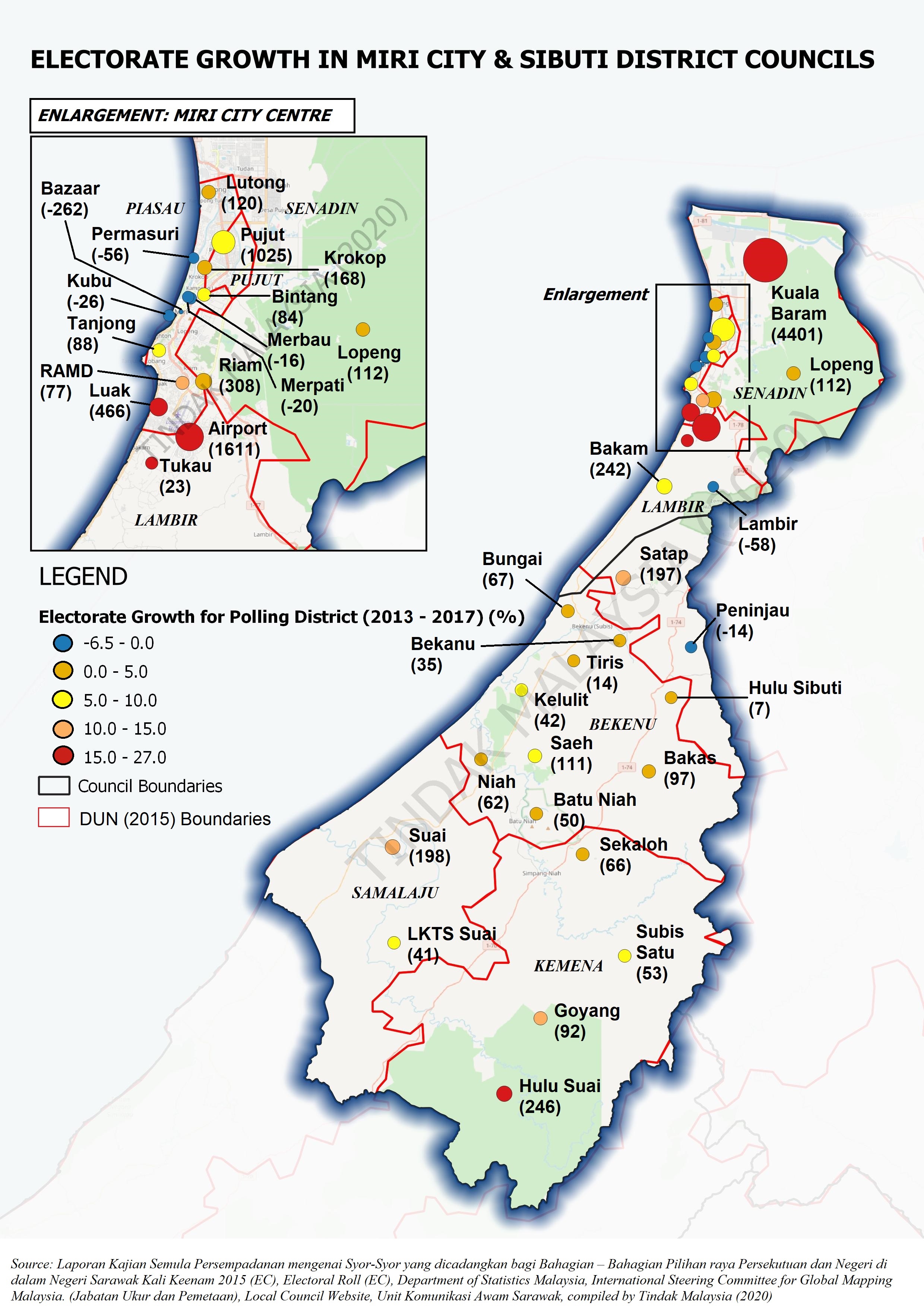
As polling district is a subset to a DUN, we notice the growth of sub regions of Samalaju, Bekenu and Kemena are largely below 200 for each polling district exception of Hulu Suai. One will notice the variation of electorate population patterns in core and new growth areas of Miri. The biggest explanation why Senadin is growing fast is because of the incredible population growth found in Kuala Baram. Currently, Kuala Baram is the largest polling district in the country with a home of more than 20 000 voters. Surprisingly, it has an electorate size bigger than the smallest parliamentary seat in the country which happens to be in Sarawak (Igan).
Asides Kuala Baram, one will notice there is strong electorate growth in Southern Miri in areas of Luak (Piasau), Riam (Senadin) and Airport (Lambir). The expansion of electorate in Lambir is largely attributed to the urban expansion of Miri appearing next to the airport. Pujut probably experiencing a population consolidation in what is an established urbanized territory. On the flip side, some of the older parts of Miri such as Kubu, Bazaar, Merpati and Merbau experiencing depopulation. This may be attributed to population shifting away from there and these areas are no longer as residential as before. Things may change in Kubu as there are new growths in commercial areas appearing there.
*For the purposes of this study, we decided not to include Bario Subdistrict (managed by Miri City Council) in the consideration due to the long geographical distance between Miri city and Bario subdistrict
For Citation: Laporan Kajian Semula Persempadanan mengenai Syor-Syor yang dicadangkan bagi Bahagian – Bahagian Pilihan raya Persekutuan dan Negeri di dalam Negeri Sarawak Kali Keenam 2015 (EC), Electoral Roll (EC), Department of Statistics Malaysia, International Steering Committee for Global Mapping Malaysia. (Jabatan Ukur dan Pemetaan), Local Council Website, Unit Komunikasi Awam Sarawak, compiled by Tindak Malaysia (2020)